CBC News
A decades-old border dispute involving Quebec and Labrador has resurfaced, this time over the management of wildlife.
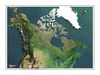
A detail from a map on a Quebec government website shows parts of southern Labrador within Quebec's jurisdiction.
(CBC) The Quebec government's website features a map illustrating some of the results of a program tracking hundreds of migrating caribou.
The program was a joint monitoring project between the governments of
Quebec and Newfoundland and Labrador.
However, a map attached to survey results — posted on the website of
Quebec's Natural Resources Department — shows large parts of southern Labrador as being inside the Quebec boundary.
John Ottenheimer, Newfoundland and Labrador's minister of
intergovernmental affairs, said the map is the latest in a line of claims
that Quebec has made about its boundary and Labrador.
"We don't like it," Ottenheimer told CBC News. "We've seen this over the
years — it happens time and time again."
On previous occasions, Quebec has sometimes used maps showing no border marking Labrador at all.
"Our province has written Quebec in the past on this issue but we take
comfort in the fact that the Constitution is on our side and the law is on
the side of this province, and we know where the border exists,"
Ottenheimer said.
The boundary between Labrador and Quebec evolved until its current form was determined by a committee of the British Privy Council in 1927.
Labrador had come under the jurisdiction of Newfoundland, at the time a
dominion affiliated with the British empire. Newfoundland entered
Confederation with Canada in 1949.
Quebec never recognized that 1927 decision, putting it at odds with the
Government of Canada.
Officials with the Quebec government did not agree to a recorded
interview, although an official with Quebec's natural resources department said maps used on the departmental website are official maps of the
province.


-

-

-
Préparer l'accession du Québec à son indépendance
Le Labrador québécois : une frontière à déterminer
Conflit d'intérêts à Londres en 1927
-

-
Entente Québec-Terre-Neuve (2009)
1927, le Québec est amputé du Labrador
Les dessous de la cession forcée du Labrador à Terre-Neuve
-
Entente Québec-Terre-Neuve (2009)
1927, le Québec est amputé du Labrador
Les dessous de la cession forcée du Labrador à Terre-Neuve
-
-
Préparer l'accession du Québec à son indépendance
Le Labrador québécois : une frontière à déterminer
Conflit d'intérêts à Londres en 1927
-

-
-
-
-
Préparer l'accession du Québec à son indépendance
Le Labrador québécois : une frontière à déterminer
Conflit d'intérêts à Londres en 1927
-
Entente Québec-Terre-Neuve (2009)
1927, le Québec est amputé du Labrador
Les dessous de la cession forcée du Labrador à Terre-Neuve
-
-
Un chemin dominé par la peur
J’attends depuis cinquante ans...
-
Le lobbyisme déprédateur dans l’administration des fonds publics par la complicité de la CAQ*
Christine Fréchette, l’imposture de continuer en politique quand sa complicité au Conseil des ministres a coûté à l’État-québécois plus d’un milliard de dollars
Le cynisme comme valeur intrinsèque de faire partie d’une formation politique désavouée par 85 % de la population**
-
Vers le troisième référendum sur la souveraineté du Québec
La « fenêtre » de PSPP
-
-

Québec-Canada: quel avenir
Le choix entre deux modèles de société
-
Société
De la forme et du fond du langage sur les médias sociaux
Je rêve depuis plus de cinquante ans…
-

Hôpitaux, écoles, routes, ponts, port, systèmes informatiques, transport en commun
Infrastructures: tout est à réparer mais on en n'a plus les moyens
Il manque 500 milliards de dollars qui ne seront jamais disponibles
-
Course à la direction de la CAQ
Christine Fréchette au diapason de la population
Jusqu’où iront les accommodements raisonnables?
-
-
Québec-Canada: quel avenir
Le choix entre deux modèles de société
-
Course à la direction de la CAQ
Christine Fréchette au diapason de la population
Jusqu’où iront les accommodements raisonnables?
-
L’État-nation du Québec, une réalité qui doit être assumée par une majorité des Canadiens Français patriotes pour que cet État devienne indépendant
Prospective impliquant la science politico-démographique et la manipulation des intentions de vote par certains sondages biaisés afin que l’indépendance du Québec soit irréalisable
Les erreurs prévalant depuis l’établissement de la politique immigratoire incompatible aux intérêts nationaux du Québec
-
Un chemin dominé par la peur
J’attends depuis cinquante ans...
-

Les anglophiles franco-européens devraient se méfier
Anglophiles et gallophobes
Ils font le jeu des gallophobes états-uniens
-
-
Deux colonialismes
L'aplomb des Groenlandais d'origine inuite m'a étonné
-

Jour du drapeau
Soulevons le drapeau
-

La Guerre de Sept Ans se poursuit
La menace venue du Sud, un déterminant de notre destin national
L'invasion américaine de 1775, rdv manqué avec...la Louisiane du Nord
-

-

Jusqu'où ira l'entrisme islamique tentaculaire et détourné?
Bientôt l'abattage halal forcé du porc du Québec?
Combattons tous ensemble cette infiltration lente et néfaste
-
Le Québec souverain est la voie de l'avenir, puisque tout le monde veut l'être
Si le Canada et le Groenland tiennent tant à leur souveraineté, pourquoi pas nous aussi au Québec?
Souveraineté pour tous, à commencer par le Québec
-

Urgent: ramener l'immigration au niveau d'il y a 25 ans
Le Québec à grand risque de surdose mortelle d'immigrants?
Sortez l'ÉpiPen et vite
-

Tout athlète québécois devrait pouvoir défendre les couleurs du Québec à l'international
Les athlètes québécois qui représentent le Canada se font-ils imposer l'identité canadienne malgré eux?
En apposant les 2 drapeaux côte à côte sur le maillot
-
La vente de la Banque Laurentienne
Un cas typique de dépossession du Québec par le fédéralisme « canadian »
L'État québécois et la Caisse de dépôt et placement du Québec doivent bloquer la vente
-
Hôpitaux, écoles, routes, ponts, port, systèmes informatiques, transport en commun
Infrastructures: tout est à réparer mais on en n'a plus les moyens
Il manque 500 milliards de dollars qui ne seront jamais disponibles
-

Trop d'abus, trop de profiteurs
L'aide sociale gratuite, universelle, automatique et illimitée doit être abolie
Il faudra remplir certaines conditions de base
-
-
Sans l’adhésion de l’État québécois aux États-Unis d’Amérique* le destin politique de la Nation Canadienne Française sera celui sous un régime sino-canadian
Pourquoi le Québec sans faire partie des États-Unis d’Amérique passera d’un régime colonialiste british-canadian à un protectorat libéro-néo-impérialiste communiste chinois
Comment le PLC-PLQ, ses complices anglo-allophones et les antipatriotes s’organisent pour anéantir la majorité politique de l’électorat canadien-français**
-

Immigration Canada à blâmer de les laisser entrer sans filtre suffisant
Pourquoi toujours plus de criminalité au Québec? parce qu'il y a toujours plus de criminels importés
comprend une liste des pays jugés dangereux à bloquer
Laissez un commentaire Votre adresse courriel ne sera pas publiée.
Veuillez vous connecter afin de laisser un commentaire.
Aucun commentaire trouvé